
The US Post Office for the community of Partridge, Kentucky is located about a mile and a half from the Letcher / Harlan County line on an old alignment of US 119. Partridge is about 5 miles north of Cumberland on US 119 and about 18 miles south of Whitesburg in Letcher County.
Tag: Appalachia
Martin’s Fork Time Machine
First and foremost before I begin this entry I want to give credit and thanks to the Martins Fork Lake Facebook page for sharing these photos. Ever since I was small I have always wondered what the land looked like before the lake was built at Smith. So, with great gratitude I thank the folks who control the lake’s social media page for having the thoughtfulness and courtesy to share these wonderful archives with us.
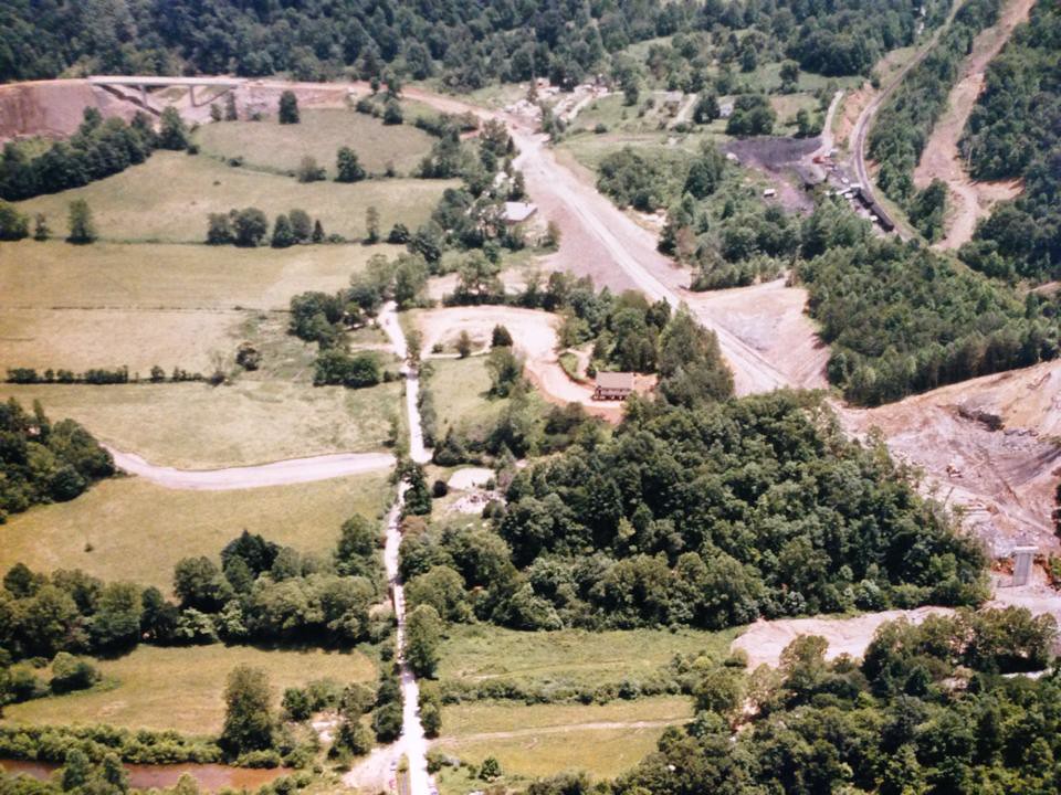 Im starting off the photos with what I consider to be the holy grail of the bunch. This photo is looking toward the bridge nearest the beach. Imagine that little road running up and down the middle is the road along the beach area. If you look closely you can see the roof of the old Smith School and the rock church near the center. Im shocked at how flat this area was.
This second picture is looking off toward the lake from the last bridge. In fact, to this day, if the water is down far enough you can still tell where this bridge was that is in the picture.
 The rest of the photos are pretty self explanatory, but fascinating no doubt.
The last picture is an old welcome sign that was at the lake until the 1980s according to the lake’s Facbook page.

I also have a couple of other entries that includes more historical pictures from Martins Fork Lake and the Smith community that I posted a few years ago, if you are interested in reading those articles you can do so by clicking the links below:
Diving Into The Archives
Recently, and by recently I mean within the past 72 hours, I have been exposed to a vast array of historic aerial photography archives from my home town that are readily (with a fee) available to the public from as far back as 1952. The first that I decided to purchase is this shot:
 For comparison as to what you are looking at here is the same image marked with where my house is now.
For even further reference for anyone familiar (IE family) Here is notations of what each building was that showed up on the land in 1952.
 None of these structures are still around today. Its really neat to see a visual representation, especially from the air to show what I have heard my grandmother and my parents and aunts and uncles talk about for years and years. For a representation of how things have changed in this little community I took a screen shot of the most recent google earth image (fall 2016) from the same exact location
If you notice in the 1952 photos the road has clearly just been constructed as the banks where they blasted the mountain off hasnt grown back at all. You can also make out the old road if you look close enough. According to my dad the old road crossed the river right across from my house and went across and around the other side of the river. You can see that the culvert right by my house has clearly not even been installed yet. Its amazing to me that you can find things such as this on the internet. A lot has changed in 65 years. If you would like more information about these aerial photography archives visit the site by clicking HERE
Little Switzerland, North Carolina 28749
Little Switzerland is located in Mitchell and McDowell Counties in Western North Carolina just off the Blue Ridge Parkway. The elevation is around 3,200 feet.

The immediate area was settled in 1909 and Little Switzerland was founded in 1909. In 1927 the first Post Office was built.
Fuji Instax Wide Meets The Blue Ridge Parkway
 A couple of weeks ago my best friend and I took a ride on the Blue Ridge Parkway from Town Mountain Road in Asheville up to Little Switzerland. I took my Fuji Instax Wide along for the trip and got some pretty good results.
 The Fuji Instax film definitely loves to bring out the blues and greens.
Flag Pond School — Unicoi County,Tennessee
Flag Pond Elementary School was located in the Unicoi County community of Flag Pond, high up in the deep mountains of extreme eastern Tennessee bordering North Carolina.
 The current Flag Pond School was created when Rocky Fork School and Sweetwater School were consolidated.
Interestingly enough, another earlier school was located in the community called “Hog Skin”.
 Today the Flag Pond School sits empty and although has been that way for around 20 years, it still seems to be secured and maintained. The grounds of this school is home to the annual ramp festival which is held on the second Saturday of May each year. Information about this past years festival can be found by clicking HERE

Welch, West Virginia
Welch is the county seat of McDowell County, the southern most of the West Virginia counties.
 The city was incorporated in 1893. Welch was made the county seat of McDowell County by the voters in 1892. Until that point the county seat was Perryville which was located on present day West Virginia Route 83 along the Dry Fork. Results of the election were contested so to avoid violence county records were secretly moved from Perryville to Welch at night in two wagons by James A. Strother and Trigg Tabor.

Kmart — Boone, North Carolina
 The Kmart in Boone, North Carolina was located at 1620 Blowing Rock Road. The store first opened its doors on March 14, 1979.
On June 16, 2014 it was announced that the Kmart in Boone would close its doors in mid-September.
 The store closed for good on Sunday September 7, 2014.


Demolition began in March 2016 and construction has began on a new Publix store that will open on the site in 2017.


Harvest Moon 2016
The Harvest Moon is the full moon that occurs closest to the autumnal Equinox. The This particular full moon is called the harvest moon because farmers can continue their harvest late into the night by the light of the full moon. There is also data that shows some birds rely on the Harvest moon to migrate from one area to another. They have also proven that the birds wait for this moon to begin their migration.
 These particular photos were taken from my front porch tonight. Enjoy.
Impossible Project Third Man Records Film

These shots were taken with the Polaroid One Step 600 camera using fresh Third Man Records edition black and yellow film.

For some reason my scanner didnt want to cooperate and scan the black frame, instead it must have thought that nothing was there on some of the pictures.


